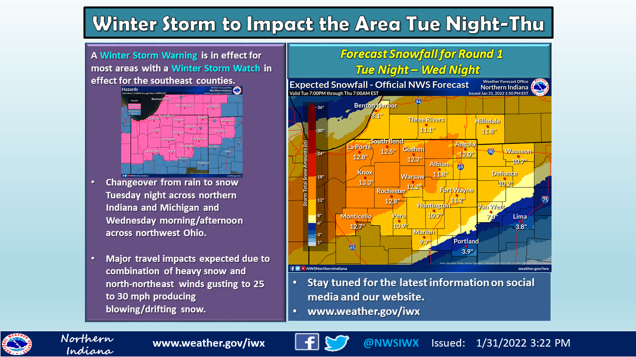
The National Weather Service of Northern Indiana and Chicago have issued Winter Storm Warnings for the area.
For the counties of La Porte, St. Joseph, Elkhart, Lagrange, Steuben, Noble, Starke, Pulaski, Marshall, Fulton, Kosciusko, Berrien, Cass, Branch, Hillsdale
Update: 1134 PM EST Mon Jan 31 2022
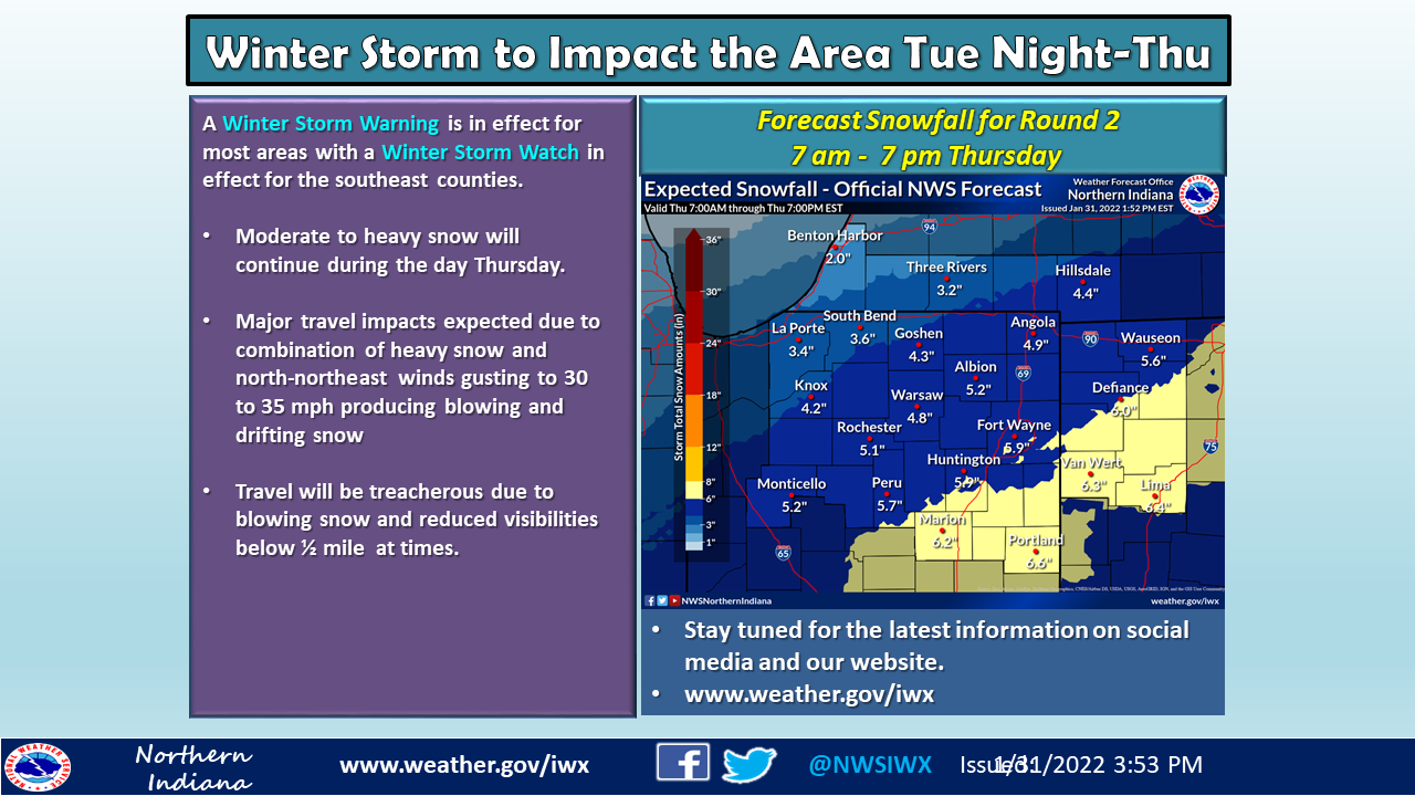
…WINTER STORM WARNING REMAINS IN EFFECT FROM 1 AM EST /MIDNIGHT
CST/ WEDNESDAY TO 7 PM EST /6 PM CST/ THURSDAY…
* WHAT…Heavy snow and dangerous travel expected. Total snow
accumulations in excess of 10 inches.
* WHERE…Portions of northern Indiana and southwest Michigan.
* WHEN…From 1 AM EST /midnight CST/ Wednesday to 7 PM EST /6
PM CST/ Thursday.
* IMPACTS…Travel will become very difficult to impossible.
Blowing snow could significantly reduce visibility. The
hazardous conditions will affect Wednesday and Thursday
commutes.
* ADDITIONAL DETAILS…Rain will change to snow from northwest
to southeast early Wednesday morning. This will be a long
duration snow event, with periods of moderate to heavy snow
and reduced visibilities.
PRECAUTIONARY/PREPAREDNESS ACTIONS…
If you must travel, keep an extra flashlight, food, and water in
your vehicle in case of an emergency.
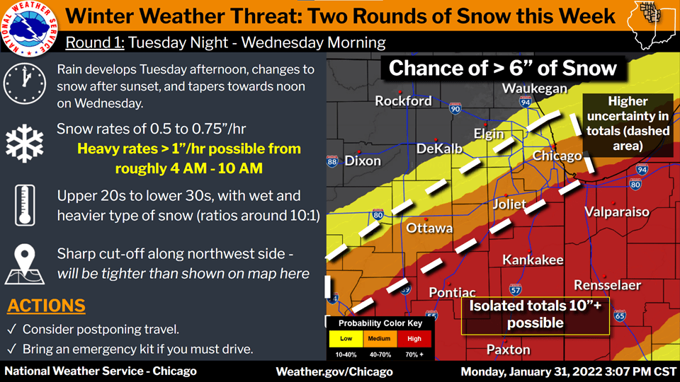
For the counties of Porter, Lake, Kankakee, Livingston
Update: 928 PM CST Mon Jan 31 2022
…WINTER STORM WARNING REMAINS IN EFFECT FROM 10 PM CST /11 PM
EST/ TUESDAY TO 6 PM CST /7 PM EST/ THURSDAY…
* WHAT…Heavy snow and hazardous travel conditions expected.
Total snow accumulations of 6 to 12 inches possible through
Wednesday. An additional 3 to 6 inches of snow is possible
from Wednesday night through Thursday.
* WHERE…Portions of northwest Indiana and east-central
Illinois.
* WHEN…From 10 PM CST /11 PM EST/ Tuesday to 6 PM CST /7 PM
EST/ Thursday.
* IMPACTS…Travel will be very difficult to impossible. The
hazardous conditions will impact both the morning and evening
commutes on Wednesday.
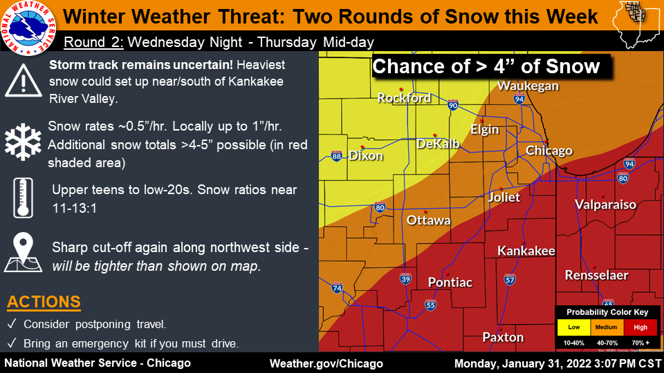
* ADDITIONAL DETAILS…Heavy snow is expected Tuesday night
through Wednesday, with the potential for another round of heavy
snow late Wednesday night through Thursday. A break in the
heaviest snow rates may occur Wednesday evening.
PRECAUTIONARY/PREPAREDNESS ACTIONS…
If you must travel, keep an extra flashlight, food, and water in
your vehicle in case of an emergency.