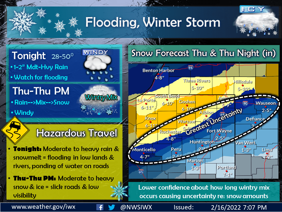
Multiple winter storm warnings, lake shore flood advisories, and a flood watch are in effect in the area.
A winter storm warning is in effect for the Counties of La Porte, St. Joseph IN, Elkhart, Lagrange, Starke, Marshall, Berrien, Cass MI, St. Joseph MI:
“…WINTER STORM WARNING REMAINS IN EFFECT FROM 8 AM EST /7 AM
CST/ THURSDAY TO MIDNIGHT EST /11 PM CST/ THURSDAY NIGHT…
* WHAT…Mixed precipitation into mid morning followed by heavy
snow expected. Total snow accumulations of 5 to 9 inches and
ice accumulations of around one tenth of an inch. Winds
gusting as high as 40 mph with considerable blowing snow.
* WHERE…Portions of northern Indiana and southwest Michigan.
* WHEN…From 8 AM EST /7 AM CST/ Thursday to midnight EST /11
PM CST/ Thursday night.
* IMPACTS…Travel will become very difficult. The hazardous
conditions will impact the Thursday evening commute.
PRECAUTIONARY/PREPAREDNESS ACTIONS…
If you must travel, keep an extra flashlight, food, and water in
your vehicle in case of an emergency.”
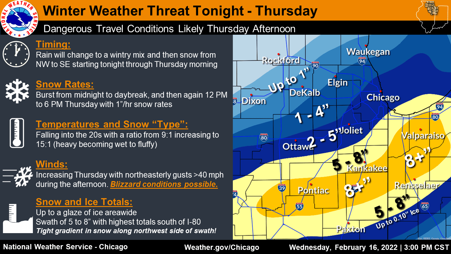
Winter Storm Warning for Lake, Porter and Portions of Chicago area:
A Winter Storm Warning is in effect for the counties of Porter and Lake in Indiana and the counties of La Salle, Kendall, Grundy, Kankakee, Livingston, Southern Cook, Northern Will, Southern Will, Eastern Will in Illinois.
“…WINTER STORM WARNING REMAINS IN EFFECT FROM 3 AM TO 9 PM CST
THURSDAY…
* WHAT…A period of accumulating snow, freezing rain and sleet
expected late tonight through daybreak Thursday. After a lull
in wintry precipitation for much of Thursday morning, heavy
snow is expected to develop Thursday afternoon into early
Thursday evening. Total snow accumulations of 3 to 8 inches
expected, highest south of the Illinois and Kankakee rivers.
Ice accumulations up to one tenth of an inch expected. North
winds gusting to 45 mph along the Lake Michigan shore and 40
mph elsewhere Thursday afternoon and early evening.
* WHERE…Portions of northwest Indiana and central, north
central and northeast Illinois.
* WHEN…From 3 AM to 9 PM CST Thursday.
* IMPACTS…Plan on slippery road conditions for the Thursday
morning commute. Travel during the afternoon and evening will
become very difficult or treacherous from heavy snow and
widespread blowing snow and drifting, especially in open areas.
* ADDITIONAL DETAILS…Snowfall rates greater than one inch per
hour at times are expected Thursday afternoon. The high
snowfall rates combined with the strong winds will result in
very low visibility and may cause sporadic power outages from
strain on tree limbs and power lines.
PRECAUTIONARY/PREPAREDNESS ACTIONS…
If you must travel, keep an extra flashlight, food, and water in
your vehicle in case of an emergency.
In Illinois, the latest road conditions for Illinois can be
obtained on the internet at www.gettingaroundillinois.com. In
Indiana, the latest road conditions for Indiana are available by
calling 1-800-261-7623.”
A Winter Storm Warning for the Counties of Newton, Jasper, and Benton in Indiana and Iroquois and Ford counties in Illinois
“…WINTER STORM WARNING REMAINS IN EFFECT FROM 6 AM CST /7 AM
EST/ TO 9 PM CST /10 PM EST/ THURSDAY…
* WHAT…A period of accumulating freezing rain and sleet is
expected Thursday morning before transitioning to heavy snow
Thursday afternoon and early evening. Total snow accumulations
of 6 to 10 inches and ice accumulations up to two tenths of an
inch. North winds gusting as high as 40 mph in the afternoon
and evening.
* WHERE…In Indiana, Newton, Jasper and Benton Counties. In
Illinois, Ford and Iroquois Counties.
* WHEN…From 6 AM to 9 PM CST Thursday.
* IMPACTS…Plan on slippery road conditions Thursday morning.
Travel during the afternoon and evening will become very
difficult or treacherous due to widespread blowing and
drifting snow, especially in open areas.
* ADDITIONAL DETAILS…Several hours of snowfall rates greater
than one inch per hour are expected Thursday afternoon. The
high snowfall rates combined with the strong winds will result
in very low visibility and may cause sporadic power outages
from strain on tree limbs and power lines.
PRECAUTIONARY/PREPAREDNESS ACTIONS…
If you must travel, keep an extra flashlight, food, and water in
your vehicle in case of an emergency.
In Illinois, the latest road conditions for Illinois can be
obtained on the internet at www.gettingaroundillinois.com. In
Indiana, the latest road conditions for Indiana are available by
calling 1-800-261-7623.”
A Lakeshore Flood Advisory is in effect for La Porte County
“…LAKESHORE FLOOD ADVISORY REMAINS IN EFFECT FROM 7 AM THURSDAY
TO 6 AM CST FRIDAY…
* WHAT…Waves of 6 to 10 feet, occasionally to 13 feet will
likely cause minor beach erosion and lakeshore flooding.
* WHERE…La Porte county.
* WHEN…From 7 AM Thursday to 6 AM CST Friday.
* IMPACTS…Parking lots and roads along the immediate lakeshore
will experience minor flooding. Minor erosion of beaches and
sand dunes is expected.
PRECAUTIONARY/PREPAREDNESS ACTIONS…
A Lakeshore Flood Advisory indicates that onshore winds will
generate flooding of low areas along the lakeshore. Some minor
beach and dune erosion is also likely.”
A Lakeshore Flood Advisory is in effect for Lake and Porter counties
“…LAKESHORE FLOOD ADVISORY REMAINS IN EFFECT FROM 6 AM THURSDAY
TO 6 AM CST FRIDAY…
* WHAT…Large battering waves 10 to 14 feet. Waves of this
magnitude will result in renewed shoreline erosion, lakeshore
flooding, and dangerous conditions near the lakefront.
* WHERE…Lake IN and Porter Counties.
* WHEN…From 6 AM Thursday to 6 AM CST Friday.
* IMPACTS…Flooding of property along the lakeshore including
parts of the Whiting Lakefront Park are likely, with flooding of
some low lying roads possible. Freezing spray could also lead to
ice accumulation on surfaces near the lake.
PRECAUTIONARY/PREPAREDNESS ACTIONS…
Residents on or near the shore should take appropriate action to
protect property from rising water levels.”
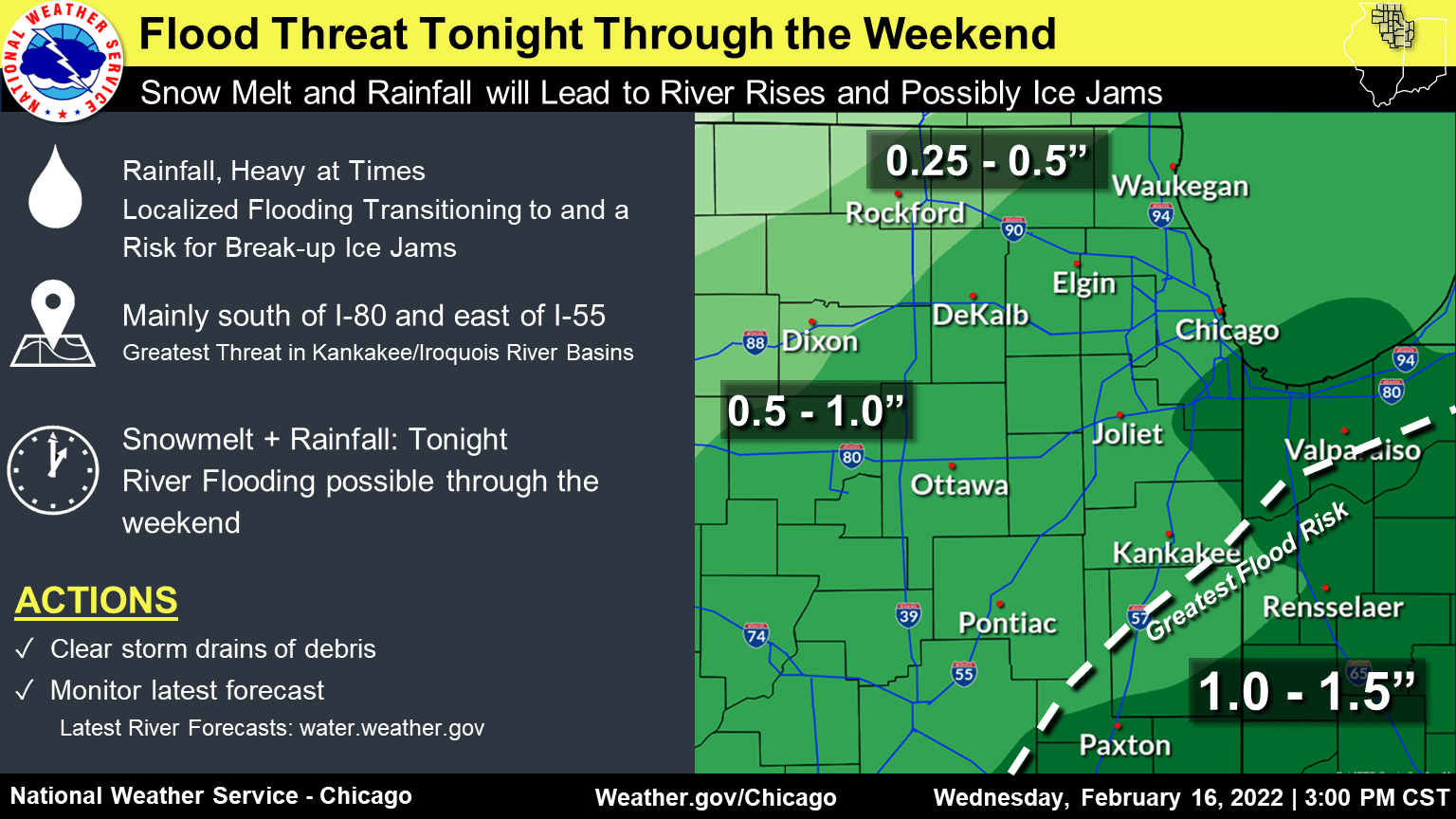
A flood watch is in effect for the Counties of Newton, Jasper, and Benton in Indiana and Iroquois and Ford counties in Illinois
“…FLOOD WATCH REMAINS IN EFFECT THROUGH THURSDAY MORNING…
* WHAT…Flooding caused by heavy rain, snowmelt, and break-up ice
jams continues to be possible.
* WHERE…Portions of east central Illinois and northwest Indiana,
including the following counties, in east central Illinois, Ford
and Iroquois. In northwest Indiana, Benton, Jasper and Newton.
* WHEN…Through Thursday morning.
* IMPACTS…Excessive runoff may result in flooding of rivers,
creeks, streams, and other low-lying and flood-prone locations.
Creeks and streams may rise out of their banks. Some rivers are
forecast to go above flood stage based upon current forecast
rainfall. Rising river levels may result in river ice becoming
dislodged, increasing the risk of localized break-up ice jams.
* ADDITIONAL DETAILS…
– Rainfall of one to one and a half inches is expected tonight
into Thursday morning in addition to runoff from melting
snow. Frozen ground may lead to quick runoff.
– https://www.weather.gov/safety/flood
PRECAUTIONARY/PREPAREDNESS ACTIONS…
A Flood Watch means flooding is possible, but not yet certain, based
upon the latest forecasts. Persons with interests along area rivers,
creeks, and other waterways should monitor the latest forecasts and
be prepared to take action should flooding develop.”